Article Text

Abstract
Background Determining the locations of disaster emergency shelters and the allocation of impacted residents are key components in shelter planning and emergency management. Various models have been developed to solve this location–allocation problem, but gaps remain regarding the processes of hazards. This study attempts to develop a model based on the change of typhoon track that addresses the location–allocation problem for typhoon emergency shelters.
Purpose To consider the changes in candidate shelters and number of evacuees due to the change in impact area with the progression of a typhoon.
Methods The proposed model is composed of several static processes and solved by a modified particle swarm optimisation algorithm with a restart strategy.
Results The model is illustrated with the case of the evacuation process for Wenchang in Hainan province during Typhoon Rammasun in 2014 and Typhoon Mirinae in 2016. For the case of Typhoon Rammasun in 2014, the residents from east to west need to evacuate in three phases. For the case of Typhoon Mirinae in 2016, residents in the northern communities need not to evacuate to candidate shelters because they are not affected by the typhoon.
Conclusion The proposed model has advantages compared with non-typhoon track change–based model in saving time spent in shelters for residents and saving public resources for the local governments. With the proposed model, a manager could efficiently evacuate residents by considering the typhoon conditions.
- emergency shelter
- location and allocation model
- typhoon track
- modified PSO algorithm
This is an open access article distributed in accordance with the Creative Commons Attribution Non Commercial (CC BY-NC 4.0) license, which permits others to distribute, remix, adapt, build upon this work non-commercially, and license their derivative works on different terms, provided the original work is properly cited, appropriate credit is given, any changes made indicated, and the use is non-commercial. See: http://creativecommons.org/licenses/by-nc/4.0/.
Statistics from Altmetric.com
Introduction
It has been demonstrated that tropical cyclone intensity increased with global warming.1 2 Typhoons striking China, Korea and Japan are predicted to further intensify, which represents an increased threat to people and property in the region3; therefore, future planning for disaster prevention is necessary.1
More and more attention has been paid to the impacts of natural disasters on our society. Numerous efforts have been made to reduce these impacts. The establishment of emergency shelters has been proven to be one of the most effective ways to reduce the causalities of natural disasters.4 5 For a long time, many countries, such as the USA and Japan, have set up disaster shelters and issue-related guidelines.6–8 With the development of computer and mathematics technology, mathematical planning methods have been widely used in disaster shelter planning to solve complex and high-dimensional location and allocation problems, such as works performed by Sherali et al,9 Dalal et al,10 Bayram et al,11 Gama et al 12 and Kilci et al.13 Optimum algorithms, such as the ant colony algorithm,14 genetic algorithm15 16 and particle swarm optimisation (PSO) algorithm,5 17–20 have also been adopted to solve the problems of disaster emergency shelter location and allocation. However, in emergency shelter location and allocation model, few studies have considered the process of hazards, which mainly determine the impact areas and number of evacuees.
This study aims to develop a typhoon track change–based shelter location and allocation model using the case of Wenchang in Hainan province, China. In this model, evacuees and candidate shelters are calculated with forecasted change of typhoon tracks. The proposed location and allocation model is then solved by a modified PSO algorithm with a restart strategy and demonstrated in Wenchang. The results show that the proposed method is effective for typhoon shelter planning and the allocation of evacuees.
The remainder of this study is structured as follows: Section 2 gives a description of the study area and data, Section 3 describes the models and algorithms for the location and allocation of typhoon shelters, Section 4 introduces the experimental results, and Section 5 exhibits the conclusion and discussion.
Study area and data
Wenchang, which is located in northeastern Hainan province, China, is severely affected by tropical cyclones. According to the Wenzhou Typhoon Network (http://www.wztf121.com/), there were 42 typhoons in total that affected Wenchang from 2004 to 2018 (figure 1). For example, Typhoon Rammasun (2014), which made landfall near Wenchang on 17 July 2014, was one of the most destructive typhoons to Wenchang. It caused 12 deaths, 410 injuries, 244 000 evacuees and a direct economic loss of 5.968 billion RMB. Typhoon Mirinae (2016), which partly affected Wenchang, made landfall near Wenchang on 26 July 2016. Typhoon Rammasun (2014) and Typhoon Mirinae (2016) are selected as the cases in this study.

Study area and typhoon tracks. (A) The geographical location of Wenchang and the tracks of typhoons that affected Wenchang from 2004 to 2018, (B) the track and impact area of typhoon Rammasun in 2014.
Wenchang has a land area of 2488 km2, accounting for 7% of the total Hainan province. The topography of Wenchang is relatively subtle, and the slopes are basically below 10 degrees. By the end of 2016, Wenchang had 17 towns, with a total population of 558 800, including 243 villages, with a population of 353 100; 47 designated typhoon emergency shelters, with a capacity of accommodating 22 859 people; and 53 other shelters (including schools and community/village centres), with a capacity of 204 410 people.
Wenchang has a national highway that connects the northern and southern regions of the city, with a total length of 6432 m. There are 4 provincial highways and 43 county and township roads, with total lengths of 211.0 km and 454.0 km, respectively. There are also 64 roads, with a total length of 71.5 km, and 97 trails, with a length of 425.1 km. The provincial, county and township roads and streets are used as candidate evacuation routes in this study. The shortest distances between each community and each shelter are calculated with the Dijkstra algorithm.
In this study, only the typhoon wind is considered. It is assumed that buildings in urban areas are strong enough for typhoon winds; thus, only 243 villages are considered as the demand points, and approximately 10% of the total population needs to evacuate based on the work of Ma et al.21
Methods
Model and setting
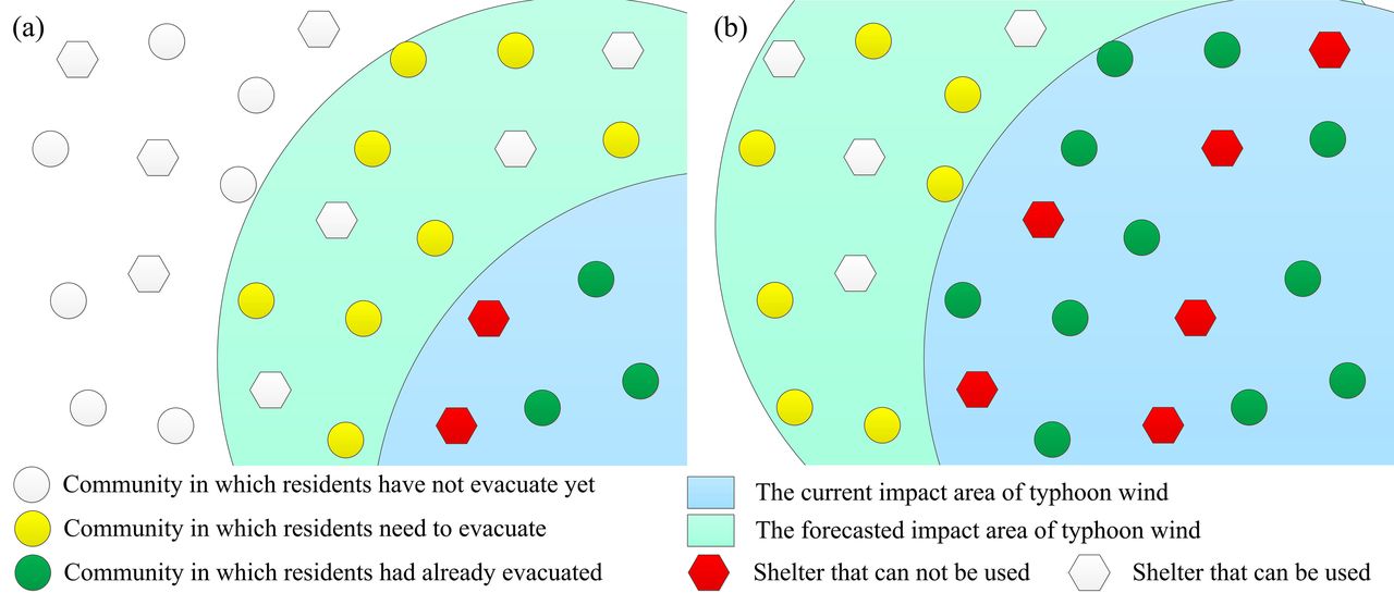
In this study, a typhoon track change–based shelter location and allocation model (TTC-SLAM) is first developed and then solved by modification of the PSO algorithm. It is assumed that the residents in buildings that have poor anti-wind capacity within 33 kt (Beaufort scale force 7) are assumed to evacuate, and the roads in the area are not recommended as evacuation routes. The region is sequentially affected by a wind force scale of 7 as a typhoon moves ahead. It is also assumed that residents will not evacuate very early but just before the typhoon comes to make the evacuation more efficient. Figure 2 shows the assumption of the evacuation procedure.

Status of shelters and communities during the evacuation process. (A) The first phase t0 and (B) the second phase t1.
In the first phase t0 (figure 2A), the current wind force covers two shelters (red hexagons) and three communities (green circles). Due to security issues, these two shelters cannot be used as candidate shelters in this phase, and the residents in these two shelters need to evacuate in the previous phase. According to the forecast, the residents in nine communities (yellow circles) will be affected during the next phase (t1); thus, the residents in these nine communities need to finish evacuating before the typhoon arrives. For these communities, all shelters that are outside of the area of the current wind force (white regular hexagons) can be used as candidate shelters.
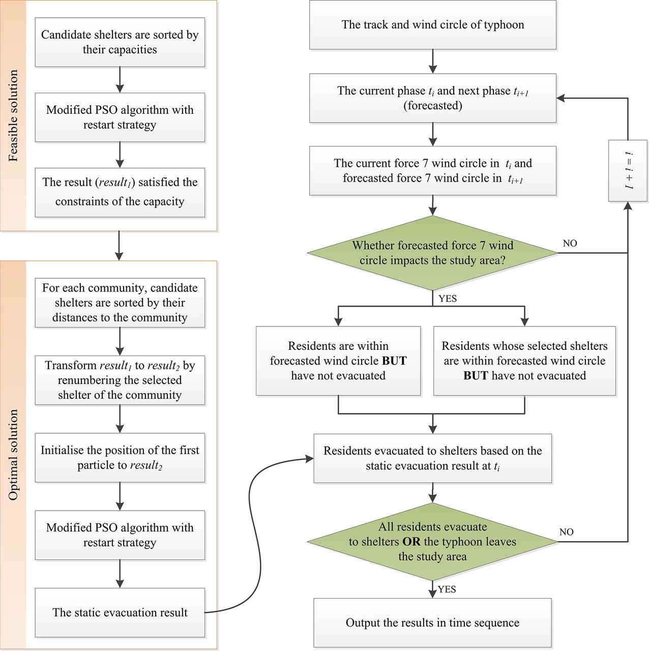
The proposed TTC-SLAM is based on a static model for each phase, and the detailed process is shown in figure 3.

Flow diagram of the proposed TTC-SLAM. PSO, particle swarm optimisation.
In the first step, a static model for each stage is first developed and then solved by the modified PSO algorithm (left part of figure 3). First, the candidate shelters are sorted by their capacities to find a feasible result ( ) for the candidate shelter to satisfy the capacity constraints (ie, to ensure that evacuees in each community can evacuate safely to shelters). Then, the optimal solution is obtained by the modified PSO algorithm. After that, for each community, the candidate shelters are sorted by their distances to the community. The feasible result (
 ) is set as the initial value for identifying a better result with a lower total evacuation distance by the modified PSO algorithm. Thus, the optimal result of the static process can be obtained, which is used as the base of the TTC-SLAM. The details of the static model and the algorithm of the modified PSO are presented in Section 3.2 and Section 3.3, respectively.
In the second step, the TTC-SLAM is developed by combining the static evacuation result and the process of a typhoon. In an evacuation process, in addition to the basic evacuation results of the static processes, the locations of the typhoon centre and wind force radius for both the current and forecasted phases are the initial inputs. The roads within the area of the current wind force are assumed to be forbidden for travel (ie, all residents in the communities within the current area of the wind force should evacuate to the candidate shelters during the previous phase, and all shelters inside the area of the wind force should not be used as candidate shelters). All communities within the area of the next-phase wind force should evacuate to candidate shelters, and communities that are not covered by the next-phase wind force should also evacuate to candidate shelters if these candidate shelters are in the area of the next-phase wind force. If all residents in the communities evacuate to candidate shelters, or the typhoon leaves the study area, the processes of the location and allocation end. Detailed processes of the proposed TTC-SLAM are shown in figure 3.
Static model formulation
It is assumed that all residents in a community are concentrated at its centre and assigned to one candidate shelter, and would evacuate by car at the same speed. Therefore, the evacuation time only depends on the evacuation distance. Thus, a location model with a single objective to minimise the total weighted evacuation distance was proposed. The model has the constraints of service distance and shelter capacity.
 (1)
(1)
Subject to
 (2)
(2)
 (3)
(3)
 (4)
(4)
 (5)
(5)
 (6)
(6)
The sets, variables and parameter definitions in this model are as follows:
I
: the set of candidate shelters:  ;
;
J
: the set of communities:  ;
;
 : the length of the shortest path between community
j
and shelter
i
;
: the length of the shortest path between community
j
and shelter
i
;
 : the maximal evacuation distance for evacuees in community
j
;
: the maximal evacuation distance for evacuees in community
j
;
L : the smallest refuge area per capita (1 m2/person);
 :represents the number of evacuees in community
j
;
:represents the number of evacuees in community
j
;
 : the remaining area of candidate shelter
i
.
: the remaining area of candidate shelter
i
.
Equation (1) is the objective function
f
to minimise the total weighted evacuation distance. The total evacuation distance is minimised subject to the capacity constraint expressed in equation (2) and the distance constraint expressed in equation (3). The capacity constraints require that the areas of the shelters should satisfy the demands of evacuees. The distance constraint requires that the distance from community
j
to a potential shelter
i
should not be farther than a specified maximal distance. Equation (4) ensures that each community can only select one shelter. Equation (5) and equation (6) represent  and
and  , which can only be equal to 0 or 1, respectively.
Base of the modified PSO algorithm with a restart strategy
The PSO algorithm22 becomes an important tool to solve complex optimisation problems due to its advantages of fast convergence, robustness and effectiveness. The position update is a major part of the PSO algorithm for improving the efficiency of solving complex problems. An inertia weight is used in the PSO algorithm to balance both the global search and locate search.23
Although the constriction factor PSO can control the particle’s velocity efficiently and enhance the ability of local searching, it is easy to trap into the local optimum.5 A restart strategy24 can find a better solution when trapped in the local optimum. A method combining the PSO and restart strategy is proposed to solve the shelter location and allocation problem in this study. The pseudocode of the modified PSO algorithm with a restart strategy is presented in table 1.
Pseudocode of the modified particle swarm optimisation (PSO) algorithm with a restart strategy
Results
Analysis of the results
For the case of Typhoon Rammasun (2014), the schemes of the typhoon location and allocation model for different phases are shown in figure 4. The communities and their assigned shelters are connected with red lines. The blue and cyan areas represent the current and forecasted potential impact areas for 33 kt force winds (force 7 winds), respectively. According to the wind speed, the evacuation process includes three phases. In each phase, communities in the cyan area need to evacuate to shelters to ensure that they are not affected by the typhoon wind. In the first phase (t1) (figure 4A), Wenchang is not affected by the current force 7 winds but will be affected by the force 7 winds in the next phase (t2) according to the forecast. In the second phase (t2), the residents for most of the communities (in the cyan area) have to evacuate to shelters because these communities are estimated to be affected by the typhoon in the third phase (t3).

Spatial allocation results corresponding to the proposed model for typhoon Rammasun (2014). A: t1, B: t2, C: t3.
There are some intersecting lines in figure 4B. One of the major reasons is that the community has to be assigned to a shelter farther away but with increased capacity because the shelter has a nearly limited capacity for accommodating the evacuees of the community. Another reason might be that the evacuation routes do not intersect. The number of selected and unselected communities and shelters for different phases are shown in table 2. Table 3 listed 10 example shelters with their allocated communities, and evacuation distance and evacuation time for each community.
Details of the community and shelter distributions for different evacuation phases during typhoon Rammasun (2014).
Details of the communities and assigned shelters for typhoon Rammasun (2014)
As shown in table 2, there is one community outside the area of the current wind force for t1, which means that this community will be inside the area of the wind force at t2, but it is assigned to a shelter that is affected by the typhoon at t1. Thus, the residents of this community have to evacuate to a shelter during t1. The six communities outside the area of the current wind force during t2 are similar.
For the case of Typhoon Mirinae (2016), the shelter location and allocation schemes for different phases are shown in figure 5. Same as Typhoon Rammasun (2014), residents in the areas for force 7 winds are assumed to evacuate during the Typhoon Mirinae (2016). In this case, the evacuation process includes four phases. Residents in the northern communities need not to evacuate to candidate shelters because they are not affected by the force 7 typhoon wind. The result is very different from the allocation planning of conventional model, which generally considers that all residents in communities need to evacuate.

Spatial allocation results corresponding to the proposed model for typhoon Mirinae (2016).
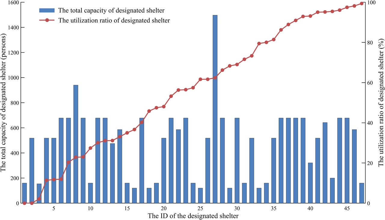
Figures 4 and 5 show that many designated shelters are not selected by the communities due to small capacity or long evacuation distance. To explore the utilisation rate of the designated shelters, the evacuation processes for the 42 typhoons (including Rammasun [2014] and Mirinae [2016]) that affect Wenchang from 2004 to 2018 are also modelled with the modified PSO algorithm. The total capacity and average utilisation ratio of the designated shelters are presented in figure 6.

Total capacity and average utilisation ratio of the designated shelters.
From figure 6, there are only two designated shelters with a capacity larger than 700. Correspondingly, there are 14 shelters with a capacity less than 200. The total capacity of the 47 designated shelters is 22 859, which is much less than the total capacity of the other shelters for 204 410 people. There are 20 designated shelters with a utilisation rate of less than 50%, including two shelters that are not selected by the communities.
Results comparison for two models
The result from the proposed TTC-SLAM is also compared with the result from non-typhoon tracked change–based model (NTTC). In the NTTC model, the objective and constraints are the same as the ones for TTC model; the difference is that for the NTTC model, the whole area is affected by the typhoon and all residents will evacuate to shelters at the same time.
The total number of communities that need to evacuate ( ), total number of selected shelters (
 ), total evacuation distance (
 ) and total time spent in shelters (
 ) from the two models are compared in this study.
The results are shown in table 4. In the case of Typhoon Rammasun (2014), the whole study area was affected, thus  for TTC model is much shorter than the one for NTTC model. In the case of Typhoon Mirinae (2016), only the south part of the study area is affected, thus the values of
  ,
,  ,
,  and
and  of TTC model are all less than that of NTTC model. The proposed TTC model shows an obvious advantage compared with the NTTC model.
Analysis of the results between the TTC model and NTTC model
Conclusion and discussion
Conclusion
In this study, a shelter location and allocation model for typhoon disasters is proposed by considering the process of a typhoon with the case of Wenchang in Hainan province. The proposed model is solved by the modified PSO algorithm with a restart strategy. For the case of Typhoon Rammasun in 2014, the evacuation processes can be divided into three phases. In the first phase (t1), Wenchang is not affected by the current force 7 winds but will be affected by the force 7 winds in the next phase (t2). In this phase, 21 communities are assigned to nine shelters. In addition, 182 communities are assigned to 64 and 12 shelters during the t2 and t3 phases, respectively. For the case of Typhoon Mirinae in 2016, residents in the northern communities need not to evacuate to candidate shelters because they are not affected by the typhoon. The value of  for TCC model is much shorter than that of NTTC model for the case of Typhoon Rammasun (2014), and the values of
  ,
,  ,
,  and
and  of TCC model are all less than that of NTTC model for the case of Typhoon Mirinae (2016). The proposed TTC model result shows an obvious advantage compared with the NTTC model; it can save time spent in shelters for residents and save public resource without arranging unnecessary evacuation for the local government. With the model, a manager could make decisions for regional shelter and evacuation planning by considering typhoon information.
Discussion
In this study, 57 public facilities such as schools and community/village centres are also considered as candidate typhoon shelters because of the limited total capacity of 47 designated shelters. For the case of Typhoon Mirinae (2016), residents in the communities that were not affected in the whole processes of typhoon do not evacuate, which can effectively save the resource due to unnecessary evacuation. In the final result of the Typhoon Rammasun (2014) case, 85 shelters in total are used, of which 43 are designated shelters and 42 are other shelters. Excluding the use of other shelters, the shelters will be overcrowded because the number of evacuees is greater than the capacities of the 43 designated shelters. In this sense, it is suggested to update other shelters to provide middle-term and/or long-term supplies, instead of building new shelters to save resources.
It has to be noted that in this study all residents in a community are assumed to evacuate to one candidate shelter for simplicity. In reality, residents in a larger community may evacuate separately to several shelters. The evacuation time greatly depends on the evacuation speed, evacuation mode and road conditions. For simplicity, residents are assumed to evacuate by car at the same speed, and road congestion is not considered in the evacuation process of this study. The differences among community size, the evacuation mode, evacuation willingness and road conditions will be considered in our future work, with the results being much closer to the real situation.
What is already known on this subject
Disaster emergency shelter location-allocation is a key component in shelter planning and emergency management.
Various models have been developed to solve location-allocation problems.
The hazard process is often not considered in disaster emergency shelter location-allocation models.
What this study adds
The proposed model considers the changes of candidate shelters and number of evacuees due to the change of typhoon track.
The proposed model is composed of several static processes and solved by the modified PSO algorithm with a restart strategy.
Two typhoons were selected to illustrate the evacuation process for Wenchang in Hainan province.
Acknowledgments
Special thanks to the anonymous reviewers and editors for their critical comments, which helped to improve the quality of this paper significantly.
Footnotes
Funding This study was funded by the Ministry of Science and Technology of the People’s Republic of China (grant nos. 2018YFC1508802 and 2016YFA0602404) and Ministry of Education and State Administration of Foreign Experts Affairs, China (grant no. B08008).
Competing interests None declared.
Patient consent for publication Not required.
Provenance and peer review Not commissioned; externally peer reviewed.